
USDA-NIFA Water for Agriculture
Research Grant:
2016-67026-25067

NSF EPSCoRNSF EPSCoR
Cooperative Agreement:
#EPS-1101342

Montana NASA EPSCoR
Research Grant:
80NSSC18M0025M
Results from our research to retrieve crop yields using remote sensing data have recently been published in the journal Remote Sensing. Accurate crop yield assessments using satellite remote sensing-based methods are critical to drive our hydro-economic models, but also for regional monitoring and the design of policies that promote agricultural resiliency and food security.
However, the application of current vegetation productivity algorithms derived from global satellite observations is generally too coarse to capture cropland heterogeneity. In this paper, we extend primary production algorithm based on light use efficiency and adapt them to retrieve agricultural productivity and crop yield by using fused MODIS-Landsat imagery within the Google Earth Engine Platform. We focus on seven important crop types across Montana in the continental USA from 2008–2015, including alfalfa, barley, maize, peas, durum wheat, spring wheat and winter wheat.
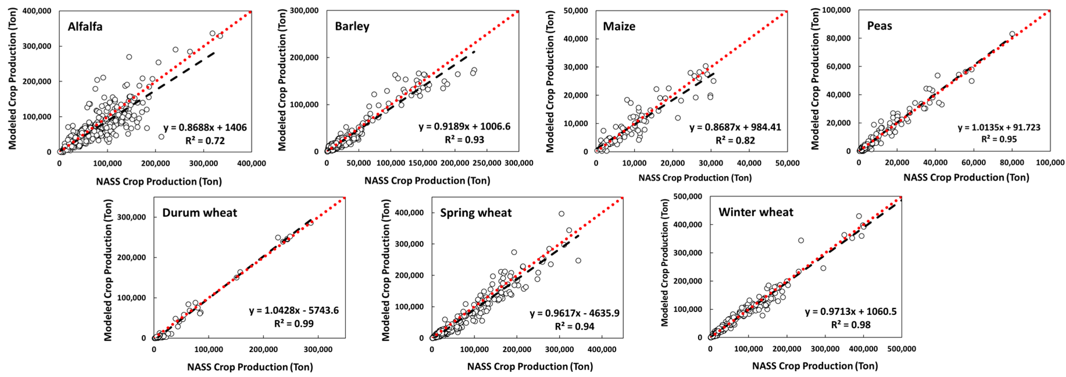
The resulting GPP estimates capture characteristic cropland productivity patterns and seasonal variations, while the estimated annual crop production results correspond favorably with reported county-level crop production data (r = 0.96, relative RMSE = 37.0%, p < 0.05) from the U.S. Department of Agriculture (USDA), see Figure 1. Our methods and results are suitable for operational applications of crop yield monitoring at regional scales, suggesting the potential of using global satellite observations to improve agricultural management, policy decisions and regional/global food security.
Further details can be found in
He, M., Kimball, J. S., Maneta, M. P., Maxwell, B. D., Moreno, A., Beguería, S., & Wu, X. (2018). Regional Crop Gross Primary Productivity and Yield Estimation Using Fused Landsat-MODIS Data. Remote Sensing, 10(3), 372; doi:10.3390/rs10030372
USDA-NIFA Water for Agriculture
Research Grant:
2016-67026-25067
NSF EPSCoRNSF EPSCoR
Cooperative Agreement:
#EPS-1101342
Montana NASA EPSCoR
Research Grant:
80NSSC18M0025M