Whitebark Pine
Mapping Abundance and Decline of a Keystone Species
Project lead: Linda Vance
Analysts: Claudine Tobalske and Joe Fortier
The whitebark pine (Pinus albicaulis) abundance and decline project was a multi-year study funded by the USDA Forest Service, Northern Region. Models were developed for five geographic areas: the Beaverhead-Deerlodge, Gallatin-Custer, Bitterroot-Lolo, Helena-Lewis and Clark, and Kootenai-Idaho Panhandle National Forests.
RandomForest models of whitebark pine distribution were developed pre- and post-beetle infestation and blister rust die-off using Landsat imagery and topographic variables. For each of the five models, a preliminary map was developed in the spring using existing whitebark location data, then used to guide field work during the summer. New locations served as additional inputs to revise the models, by correcting both commission (overmapping) and omission (undermapping) errors.
Comparing models before and after die-off is a way of spatially highlighting areas of greatest whitebark pine mortality. In the Gallatin and Custer National Forests, for example, over 50% of the trees died between 1991 and 2015.
See a poster presented at the Whitebark Pine Ecosystem Foundation's annual meeting in 2015.
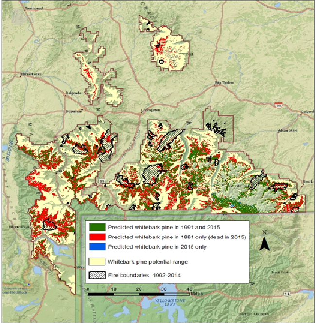 Mapped result of comparing RandomForest models for whitebark pine before (1991) and after (2015) die-off for the area just north of Yellowstone National Park, Gallatin and Custer National Forests.