Absaroka-Beartooth Mountains Represent the Roof of Montana (Part 2 of 2)

The Absaroka-Beartooth Mountains loom above the north side from Mission Creek. (Photo by Rick and Susie Graetz)
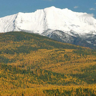
Owing to elevation of the Absaroka-Beartooth Mountains, this lofty terrain is scoured by wind and at times ferocious wea ther. Summer thunder and lightning storms accompanied by hail can be frightening at times, and snow is possible even in July and August.
Many large, high-elevation snowfields provide fertile habitat for the bloom of a microscopic algae that creates extensive patches of “pink snow.” Dissolved nutrients, the energy of the sun and carbon dioxide combine to promote reproduction and growth of the this algae.
Virtually every Montana big game animal and myriad little critters call this place home. The high lakes and streams are fabled for fishing. Brook trout are the most common, followed by cutthroat, rainbow, golden and grayling.
Once up in the rolling alpine landscape, a hiker discovers a pristine place. Here is a most magnificent environment of glistening lakes, rushing streams, waterfalls, snow, ice and, in the warm months, a wildflower display among the best in the Northern Rockies. Great views spanning idyllic mountain panoramas are everywhere. It is a world unto itself!
Numerous trails provide access along the entire fringe of the Absaroka-Beartooth. But in the high terrain, they disappear. Though these cloud-swept areas are relatively easy to negotiate, a map and compass should be used. And elevation gains, as much as distance, need to be considered when planning a trip.
From the northeast, the Stillwater drainage leads to the Lake Plateau and many day trips. On the Beartooth east face, West and East Rosebud canyons head to some of the high plateaus, as well as the Granite Peak region. Near the Red Lodge area, trails follow the West Fork and Lake Fork of Rock Creek through deep canyons up toward more lakes and towering peaks.
Entrance may be gained from several points along the Beartooth Highway, especially from just below the west side of Beartooth Pass. From the Cooke City environs, trails point toward a grouping of 12,000-foot peaks. The Kersey Lake-Broadwater Trailhead is popular for crossing the Beartooth to East Rosebud.
Lady of the Lake Trail and paths out of the Daisy Pass area, both near Cooke City, head to high lake fishing. Farther west in Yellowstone National Park, routes start from Slough Creek into Buffalo Plateau and some of the seldom-used southern reaches of the Absaroka. East of Mammoth, Hell Roaring Creek allows for a point-to-point trip across the southern Absaroka to Slough Creek.
From Paradise Valley, the Mill Creek region has many starting points into the western perimeter of the wilderness. On the north, from the Yellowstone Valley, footpaths take off from the Boulder River and switch back to both the Beartooth and Absaroka mountains.
A Beartooth wanderer needs to be ready for cold, wet weather even in summer. For finding your way, good maps and several books are available. The Rocky Mountain Survey Maps of the area are 15 minute in scale and have less detail than the USGS 7.5 minute sheets, but added features make them a good companion. Both are handy to have. Forest Service maps also are available. Falcon Press has “Hiking the Beartooth,” which lists many trails with detailed information on each. Montana Magazine’s "Beartooth Country” offers a pictorial with significant writing.
Rick and Susie Graetz | University of Montana | Department of Geography