
Satellite Data-Driven Modeling of Field Scale Evapotranspiration in Croplands Using the MOD16 Algorithm Framework
Evapotranspiration (ET) is the primary flux of water leaving the Earth’s surface and serves as a key link between Earth's energy, water and carbon cycles. Accurate ET estimates are therefore essential for monitoring global water use and informing water resource management. Unfortunately, many existing ET products are incapable of providing estimates at a fine spatial scale, global extent, and short timestep. Of the existing methods for estimating ET, remote sensing ET algorithms are the most robust, capable of providing estimates at a global scale. However, many remote sensing algorithms are very coarse spatially and temporally, making it difficult to monitor field-scale agricultural water use. To accurately estimate cropland ET at a daily time step and field scale resolution, members of our team developed a new algorithm that models ET at a 30m resolution and is calibrated for C3 and C4 crop types.
The new algorithm is based on the MOD16 ET algorithm, which uses the Penman-Monteith method to estimate ET as the sum of soil evaporation, evaporation from the wet canopy, and transpiration from plant stomata at an 8-day timestep and 500m spatial resolution. The MOD16 algorithm uses MODIS surface reflectance imagery to measure plant greenness and inform calculations of plant transpiration. In our method, we empirically fuse similar MODIS and Landsat bands to create a 30m surface greenness product. This product is then used in the MOD16 algorithm framework to estimate ET at a 30m resolution across all coterminous US (CONUS) croplands.
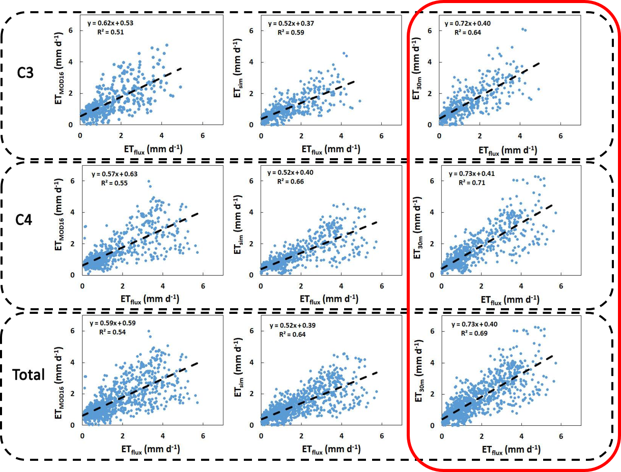
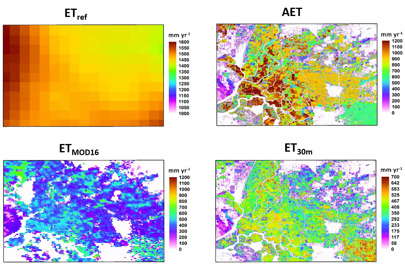
When compared to the original MOD16 product, the 30m ET algorithm shows a better correlation relative to flux tower observations (Figure 1). Additionally, the 30m ET algorithm shows lower RMSE, bias, and higher correlations than both MOD16 and actual ET (AET) estimates calculated using crop coefficients. Figure 2 shows the 30m product compared to MOD16 and AET estimates of ET within a California agricultural setting. The 30m product clearly delineates ET in individual fields, whereas the coarser MOD16 product does not. Paired with the results from figure 1, the accurate, fine scale estimates of the 30m product make it the best choice for modeling field-scale ET in United States croplands.
The 30m ET product was recently used in an analysis looking at the drivers and effects of the 2017 Northern Plains flash drought on croplands. The 30m ET product is ideal for this analysis because it can be used to isolate cropland ET. This makes it possible to look at the effects of drought exclusively in Northern Plains croplands, rather than the Northern Plains as a whole. The study found that the 30m ET product was a good indicator of drought conditions and could be used to explain some of the decreases in crop production during the drought. This analysis shows that the 30m ET product is a valuable tool for monitoring agricultural water use and tracking the effects of drought in US croplands.
For more information, refer to:
He, M., Kimball, J. S., Yi, Y., Running, S. W., Guan, K., Moreno, A., Wu, X., Maneta, M. (2019). Satellite data-driven modeling of field scale evapotranspiration in croplands using the MOD16 algorithm framework. Remote Sensing of Environment, 230 (December 2018), 111201. https://doi.org/10.1016/j.rse.2019.05.020