OpenSIMPPLLE
OpenSIMPPLLE is a spatially explicit, landscape level, dynamic simulation system that is designed as a management tool to facilitate the use of landscape ecology concepts in designing and evaluating land management alternatives for a range of planning scales.
Latest News
August 6th, 2021
Released version 1.5.1
- Fixed broken link to user guide.
- Fixed issue where GIS probability was always 0.
- Fixed incorrect orientation of LAVA.
- Fixed issue where treatment scheduler did npt display special areas or ownership.
August 13th, 2020
Released version 1.4.5
- Added a feature that allows the user to check for processes which are very unlikely to occur.
- Added prompt to the command line allowing user to overwrite or rename output files.
- Added Road Status, Landtype, and Elevation data to Slinkmetrics file.
- Fixed bug where a simulation could not be ran without selecting an output directory.
- Fixed bug where redundant density value options were displayed when editing logic data.
August 1st, 2019
Released version 1.4.4
- Fixed area label on creating new area and set the file chooser default location for the attribute to be the same as the spatial.
- Fixed null output data where multiple runs was greater than 1.
- Added a prompt and ability to overwrite simulation output.
- Fixed index out of bounds issue for report periods on CLI.
- Added catch exception for saving results when runs is greater than 1.
April 26, 2019
Released version 1.4.3
- Timestep zero now reported
- Saving pathway files to a directory no longer
overwrites directory contents
Upcoming Features
Fall 2021
- Multithreading
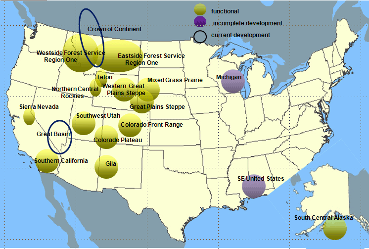
Supported Geographic Areas
The work on OpenSIMPPLLE has been partially supported by the USDA, Forest Service Northern Region, and the Rocky Mountain Research Station under agreement 12-CR-11015600-072.