

Defining Rural
Depending on the definitions used, rural areas account for 72-97% of the total landmass of the United States and approximately 14-20% of the population. Yet, people living in rural areas represent a higher percentage of people who are unemployed, living in poverty, are elderly, and experience a disability. Further, individuals with disabilities living in rural areas face unique challenges in acquiring services and supports.
An accurate, precise, and standardized definition of rural is necessary to develop effective policies and deliver meaningful services. Such a task is difficult because there are multiple definitions used by various governmental and non-governmental agencies.
Why Do These Definitions Matter?
The U.S. government manages a range of programs that are geared toward serving residents of rural areas. Whether or not an area meets a program’s criteria for “rural” will determine who is eligible for those services. For example, the U.S. Department of Agriculture (USDA) manages various rural development programs and grants for accessing housing, community development, small business development, utilities management, and more. All these USDA programs are only available to communities that meet certain rural eligibility requirements. Other federal agencies and organizations may use a different definition of rural. Therefore, it is useful to know what the different definitions are and how your county and/or community is classified.
U.S. Census Bureau
-
The U.S. Census Bureau’s urban-rural classification is fundamentally a delineation of geographical areas, identifying both individual urban areas and the rural areas of the nation. The Census Bureau’s urban areas represent densely developed territory and encompass residential, commercial, and other non-residential urban land uses.
For the 2010 Census, an urban area will comprise a densely settled core of census tracts and/or census blocks that meet minimum population density requirements, along with adjacent territory containing non-residential urban land uses as well as territory with low population density included to link outlying densely settled territory with the densely settled core. To qualify as an urban area, the territory identified according to criteria must encompass at least 2,500 people, at least 1,500 of which reside outside institutional group quarters. The Census Bureau identifies two types of urban areas:
- Urbanized Areas (UAs) of 50,000 or more people
- Urban Clusters (UCs) of at least 2,500 and less than 50,000 people
- “Rural” encompasses all population, housing, and territory not included within an urban area
Census Bureau’s map of Urbanized Areas and Urban Clusters, 2010
Office of Management and Budget (OMB)
-
The Office of Management and Budget (OMB, 2013) classifies individual counties as metropolitan counties (“urban”) and nonmetropolitan counties (“rural”). Nonmetropolitan (rural) counties can be further split into two categories: micropolitan and noncore counties.
Metropolitan Counties
Metropolitan counties consist of at least one urbanized area of 50,000 or more population, plus adjacent territory that has a high degree of social and economic integration with the core as measured by commuting ties.
Nonmetropolitan Counties
Nonmetropolitan counties consist of some combination of open countryside, rural towns (places with fewer than 2,500 people), and urban areas with populations ranging from 2,500 to 49,999. Two types of nonmetropolitan counties are:
- Micropolitan Counties: Micropolitan counties have at least one urban cluster of at least 10,000 but less than 50,000 population, plus adjacent territory that has a high degree of social and economic integration with the core as measured by commuting ties.
- Noncore counties: Noncore counties are those that do not have an urban core population of 10,000 or more. These counties are considered the most rural of this designation.
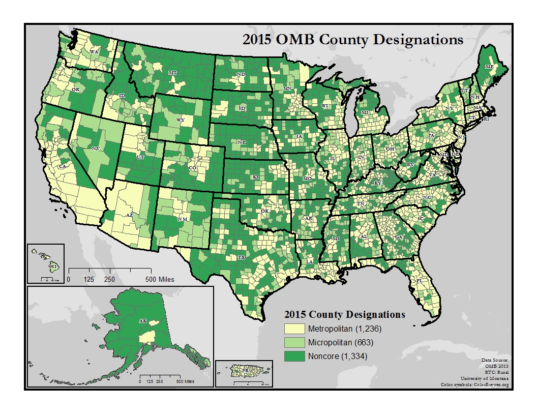
Map of OMB Metropolitan, Micropolitan, and Noncore counties across America:
This map of the United States depicts urban and rural counties across America using the Office of Management and Budget classifications. In general, Metropolitan counties (1,236 counties) are more prevalent along both the Atlantic and Pacific coasts, and throughout the eastern and midwestern states. Micropolitan (663 counties) and Noncore (1,334) counties are more common in the Northeast, parts of the northern Midwest, the Great Plains, and the Rocky Mountain region.
USDA and Economic Research Service (ERS)
-
The USDA Economic Research Service typically defines rural areas as places or towns with fewer than 2,500 people.
-
The 2013 Rural-Urban Continuum Codes form a classification scheme that distinguishes metropolitan counties by the population size of their metro area, and nonmetropolitan counties by degree of urbanization and adjacency to a metro area. The official Office of Management and Budget (OMB) metro and nonmetro categories have been subdivided into three metro and six nonmetro categories.
Each county in the U.S. is assigned one of the nine codes listed below. Codes 4-9 are typically considered to be rural.
- RUCC 1: Counties in metro areas of 1 million population or more
- RUCC 2: Counties in metro areas of 250,000 to 1 million population
- RUCC 3: Counties in metro areas of fewer than 250,000 population
- RUCC 4: Population of 20,000 or more, adjacent to a metro area
- RUCC 5: Population of 20,000 or more, not adjacent to a metro area
- RUCC 6: Population of 2,500 to 19,999, adjacent to a metro area
- RUCC 7: Population of 2,500 to 19,999, not adjacent to a metro area
- RUCC 8: Less than 2,500 population, adjacent to a metro area
- RUCC 9: Less than 2,500 urban population, not adjacent to a metro area
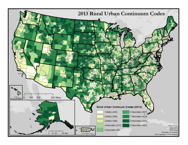
Map of Rural Urban Continuum Codes of counties across America:
To the right is a map of the United States that depicts the classification of counties across America using the United States Department of Agriculture Rural Urban Continuum Code classifications. On the map, counties are color-coded in nine levels ranging from Metro to Nonmetro. A majority of Metro counties are concentrated around major cities, in southern California, western Arizona, the Mid-Atlantic coast, and Florida. Nonmetro counties are concentrated in the Rocky Mountain and Great Plains regions. County codes are fairly variable across the rest of America.
-
The 2013 Urban Influence Codes form a classification scheme that distinguishes metropolitan counties by population size of their metro area, and nonmetropolitan counties by size of the largest city or town and proximity to metro and micropolitan areas. The standard Office of Management and Budget (OMB) metro and nonmetro categories have been subdivided into two metro and 10 nonmetro categories, resulting in a 12-part county classification. Codes 3-12 may be considered rural with 12 being the most rural.
- UIC 1: Large metro area over 1 million population
- UIC 2: Small metro area less than 1 million population
- UIC 3: Micropolitan area adjacent to large metro area
- UIC 4: Noncore area adjacent to large metro area
- UIC 5: Micropolitan area adjacent to small metro area
- UIC 6: Noncore area adjacent to small metro area with town of at least 2,500 population
- UIC 7: Noncore area adjacent to small metro area with town of less than 2,500 population
- UIC 8: Micropolitan area not adjacent to metro area
- UIC 9: Noncore area adjacent to micro area with town of at least 2,500 population
- UIC 10: Noncore area adjacent to micro area with town of less than 2,500 population
- UIC 11: Noncore not adjacent to metro or micro area with town of 2,500 population
- UIC 12: Noncore not adjacent to metro or micro area with town of less than 2,500 population
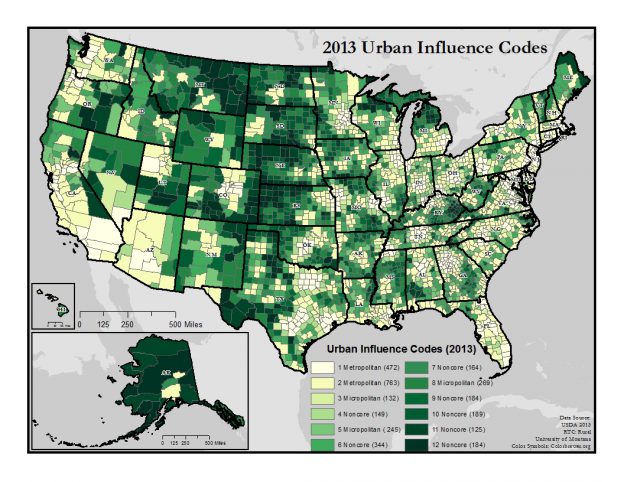
Map of Urban Influence Codes of counties across America:
To the right is a map of the United States that depicts the classification of counties across America using the United States Department of Agriculture Urban Influence Code classifications. On the map, counties are color-coded in twelve levels, identifying the counties to varying degrees of Metropolitan, Micropolitan, or Noncore status. Metropolitan counties are concentrated throughout the East, Midwest, southern Gulf Coast, southern California, western Arizona, and western Washington. Micropolitan counties are scattered across America. Noncore counties are concentrated in Alaska and the Rocky Mountain and Great Plains regions.
-
Frontier and Remote Area (FAR) codes are zip code-based, as opposed to the county- and census-based codes described above. They assist in providing policy-relevant information about conditions in sparsely-settled, remote areas of the U.S. to public officials, researchers, and the general public. This updated set of codes, based on urban-rural data from the 2010 decennial census, provides four FAR definition levels, ranging from one that is relatively inclusive (12.2 million FAR level one residents) to one that is more restrictive (2.3 million FAR level four residents).
The term “frontier and remote” is used here to describe territory characterized by some combination of low population size and high geographic remoteness. FAR areas are defined in relation to the time it takes to travel by car to the edges of nearby Urban Areas (UAs). Four levels are necessary because rural areas experience degrees of remoteness at higher or lower population levels that affect access to different types of goods and services. A relatively large number of people live far from cities providing “high order” goods and services, such as advanced medical procedures, stores selling major household appliances, regional airport hubs, or professional sports franchises. Level one FAR codes are meant to approximate this degree of remoteness. A much smaller, but still significant, number of people find it hard to access “low order” goods and services, such as grocery stores, gas stations, and basic health-care services. Level four FAR codes more closely coincide with this much higher degree of remoteness. Other types of goods and services—clothing stores, car dealerships, movie theaters—fall somewhere in between. Users are able to choose the definition that best suits their specific needs.
- FAR Level 1: includes ZIP code areas with majority populations living 60 minutes or more from urban areas of 50,000 or more.
- FAR Level 2: includes ZIP code areas with majority populations living 60 minutes or more from urban areas of 50,000 or more people and 45 minutes or more from urban areas of 25,000-49,999 people.
- FAR Level 3: includes ZIP code areas with majority populations living 60 minutes or more from urban areas of 50,000 or more people; and 45 minutes or more from urban areas of 25,000-49,999 people; and 30 minutes or more from urban areas of 10,000- 24,999 people
- FAR Level 4: includes ZIP code areas with majority populations living 60 minutes or more from urban areas of 50,000 or more people; and 45 minutes or more from urban areas of 25,000-49,999 people; and 30 minutes or more from urban areas of 10,000- 24,999 people; and 15 minutes or more from urban areas of 2,500-9,999 people.
-
The rural-urban commuting area (RUCA) codes classify U.S. census tracts based on population density, urbanization, and daily commuting patterns. Codes 4-10 are typically considered rural, with some exceptions.These codes are also used by the Federal Office of Rural Health Policy.
- RUCA 1: Metropolitan area core, local commuting within urban area
- RUCA 2: Metropolitan area high commuting, 30% out-commuting to urban area
- RUCA 3: Metropolitan area low commuting, 10%-30% out-commuting to urban area
- RUCA 4: Micropolitan area core, local commuting within large urban cluster
- RUCA 5: Micropolitan high commuting, 30% out-commuting to large urban cluster
- RUCA 6: Micropolitan low commuting, 10%-30% out-commuting to large urban cluster
- RUCA 7: Small town core, local commuting within small urban cluster
- RUCA 8: Small town high commuting, 30% out-commuting to small urban cluster
- RUCA 9: Small town low commuting, 10%-30% out-commuting to small urban cluster
- RUCA 10: Rural areas, local commuting or commuting to another rural area
Additional Resources
- "What is Rural?" from USDA's Economic Research Service
- "What is Rural?" from USDA's National Agricultural Library
- "What is Rural?" from the Rural Health Information Hub
- "Am I Rural? – Tool" from the Rural Health Information Hub
- "Defining Rural Population" from Health Resources and Services Administration (HRSA)
- "Rural America" from U.S. Census Bureau