Avon – Heart of the Little Blackfoot Valley
 Avon – Heart of the Little Blackfoot Valley
By Kilynn Groen with Rick Graetz
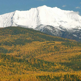
Fifteen miles up the Little Blackfoot River from Garrison Jct. and straddling US Hwy 12 sits Avon. A picturesque place, the Little Blackfoot River skirts the south perimeter of town, Nevada Creek Valley runs its course on the north, the Garnet Range begins its rise on the northeast and the Crown of the Continent’s southwest corner is just a few miles to the northeast. About 115 folks in town and 200 in the surrounding area call Avon home.
“Gold, Gold, Gold!” are the words that led to Avon’s beginnings. Between 1865 and 1866, discoveries of the precious metal in Ophir, Snowshoe, and Washington gulches attracted miners to the Little Blackfoot Valley. And these prospectors brought on inevitable ebbs and flows of people until homesteaders began trickling in.
Before prospectors made their way here, the first wagon road to cross the Rocky Mountains, the Mullan Road, passed through the site of what would become Avon. Named for US Army Lt. John Mullan who led the project, it started developing in Spring 1859 at Fort Benton, Montana head of navigation on the Missouri River and when it was completed in 1862, it covered 624 miles connecting Fort Benton with Walla Walla, Washington on the Columbia River.
Bill Cramer was one of the earliest settlers with plans to stay. In 1882, he came to know the valley while working on a survey crew for the Northern Pacific Railway making its way westward across Montana. In 1884 he returned and with other homesteaders established a town and was named the first postmaster. His original log cabin is still standing.
Welshman who settled here christened the place Avon meaning river in their native language. Most likely referring to the Little Blackfoot. “A river runs through it”.
As is the case with many towns along railroad routes, the completion of the transcontinental road was the main catalyst for the new community to take hold as Avon soon became a supply and shipping point for ranchers, homesteaders, and miners. Rails were laid through the valley in the summer of 1883. On September 8, 1883, 22 miles to the west, at Gold Creek, the last spike for the Northern Pacific was driven. Eastward building crews met those moving west.
A road on the opposite side of the highway from the railroad crossing leads to a bridge spanning the Little Blackfoot. Erected in 1914 it is a Pratt Pony Truss and has rarely been altered. The National Register recognizes that the bridge’s camelback trusses are unusual and have not been documented in other Montana bridges from the early 20th century. It seems that the contractor O.E. Peppard wanted to make a statement about Avon!
One of the historic buildings in Avon still alive with congregation and laughter today is the Community Hall. Folding chairs sit in rows as residents of the town meet for polling, celebrations, presentations, and more. It is heartwarming to see a piece of Avon’s rich history still relevant today.
Other early railroad-era commercial buildings also remain in Avon, with a frame false front building serving both as a business and the community post office. Birdseye Mercantile is an architecturally impressive stone building, dated c. 1887, that has for a decade housed a quilting business. On the outskirts of town is another look into the history of Avon. The town cemetery houses tombstones that date back to the 1880s.
North of town, off of Hwy 141 along the east banks of the Nevada Creek Lake are remnants of the historic Fitzgerald Ranch. The property started out as a simple log cabin built by Jimmy Isbel but was transformed into a magnificent array of buildings by J.F. Fitzpatrick. It was as if one were walking through a museum of architecture with his two-story Queen Anne-influenced log home, a wooden-frame barn, and other outbuildings.
Also, north of Avon, about six miles away, the McIntosh Ranch established 113 years ago is still going strong and is one of the mainstays of this rural place and an example of the strong sustainable roots that took hold.
More remnants of the past, albeit disappearing, are about three miles out of town up the Nevada Creek Valley. In the early 1940s the Anderson Phosphate Mine, later named the Cominco began operations and at one time employed upwards of 150 people until it closed in the 1970s.
Driving past the vast acres of farm and ranch land that radiate out in almost all compass directions from the community it becomes quite clear that agriculture in the form of ranching with cow-calf pairs is Avon’s economic driver. To sure some cultivation takes place, primarily to grow hay.
A long the way here and there are large metal and wood structures. perpendicular in the back and with a slope in front. This “machine”, originally named the Beaverhead Slide Stacker by its Montana’s Big Hole Valley inventors, is in essence a hay stacker. It can stack hay up to thirty feet high. Even though modern ranching technology has reduced the prominence of Beaver Slides, some ranchers are returning to use this device as a way to save money and reduce fuel usage. According to a local rancher, “loose haystacks can sit here for 10 years, and the quality of the hay will be the same, but you get any moisture in baled hay, and it will rot."
Local assets include public lands of the Beaverhead-Deerlodge and the Helena-Lewis & Clark National Forests. The closest approach to trails for hiking and backcountry skiing are on the Helena-Lewis & Clark in the unofficially named Nevada Mountains. The range carries the Continental Divide Trail, accessible from McDonald Pass, about 13 miles towards the sunrise.
And this uplift is also the southwestern segment of the Crown of the Continent Ecosystem. It gets relatively little human use in spite of the fact that every trail offers splendid views of wild country and wildlife sighting opportunities in an intact natural setting.
About 18 miles southeast of the community, in the Boulder Mountains and on the west side of the Continental Divide, springs give birth to the Little Blackfoot River as it begins its 40-mile-long journey, to where it releases its flow to the Clark Fork River near Garrison Jct. These waters provide fishing opportunities as another resource of the Avon area. Much less visited then the better known “Big Blackfoot”, it is recognized for excellent fly fishing.
Aside from the Community Center citizen’s also gather at the Avon Family Cafe. An attractive interior and a big wood stove draw area residents, especially in cold weather. Chances are that any given time, local ranchers might be gathered to talk about the price of cattle or hay or the weather. And folks regularly travelling between Missoula and Helena make the café a must stop.
Avon, with its past still in sight, and sitting in a peaceful river valley with a mix of pleasing topography, make this place part of the “Real Montana”.
----------------------------------------------------------------------------------------------------------------------
We thank Lynn and John Price for their help with current and historical information.
Kilynn Groen is a UM Honors College student, and a Research Assistant with UM’s This is Montana program. Rick Graetz is a member of UM’s Honors College faculty.