
Impacts of the 2017 Northern Plains Flash Drought Informed by Satellite Evapotranspiration
An analysis done by our team on the drivers of the 2017 Northern Plains flash drought has been released in Environmental Research Letters. The study uses satellite observations of evapotranspiration and crop productivity to explain how the drought affected agriculture in the Northern Plains.
In the summer of 2017, a severe flash drought occurred in the Northern Plains, affecting large parts of Montana, North Dakota, South Dakota, and Wyoming. The drought was characterized by low soil moisture, high temperatures and increased evaporative demand across the region. Some of the most pronounced effects of the drought were experienced by the agricultural industry. In the Northern Plains states, approximately 30% of the total land cover is croplands and agriculture is the most dominant economic industry. As a result, the flash drought had a notable effect on crop prices and production across the region.
A combination of satellite observations of evapotranspiration (ET) and productivity, meteorological data, and crop price data were used to better understand how water use and productivity in Northern Plains agriculture was affected by the flash drought. The 30m ET product developed by He et al (2019) was used to assess field-scale water use changes, the GOME-2 Solar-induced chlorophyll fluorescence (SIF) product to assess regional-scale vegetation productivity, and the Gridmet meteorology product to track regional changes in climate conditions across the Northern Plains.
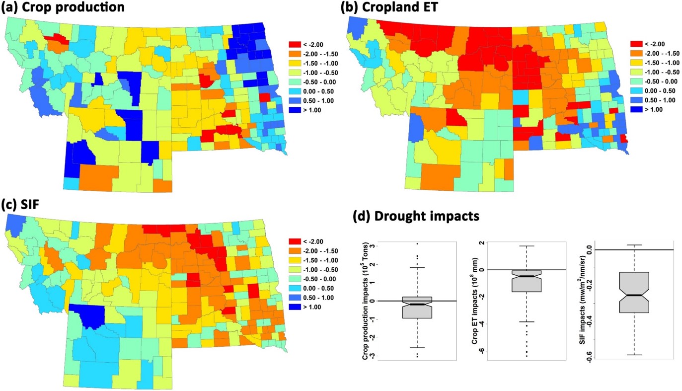
The analysis found that in the summer leading up to the flash drought, there was less precipitation and a large number of days with temperatures and vapor pressure deficits above the 2008 - 2017 historical average. These meteorological anomalies were directly proportional to ET and SIF anomalies, suggesting that there was a significant moisture constraint on vegetation productivity during the drought, as confirmed by our previous analysis using soil moisture retrievals from the SMAP mission. The negative ET and SIF anomalies also coincided with a large decrease in the 2017 crop value, likely due to the reliance on rainfed agriculture throughout large portions of the Northern Plains. Finally, ET and SIF anomalies were positively correlated with county-level production data from the National Agricultural Statistics Service, suggesting that our methodology could be effective for monitoring the onset and effects of drought in the future (Figure 1).
Drought is becoming more frequent and more servere as a result of climate change. This increase in drought is expected to have a negative impact on the agricultural industry and could potentially lead to large economic losses. Additionally, drought is notoriously complex and difficult to track with our current monitoring infrastructure. This study shows that satellite observations are an effective method for monitoring drought and could be used in the future for early recognition and tracking of drought across the United States.
For more information, refer to:
He, M., Kimball, J. S., Yi, Y., Running, S., Guan, K., Jencso, K., Maxwell, B., Maneta, M. (2019). Impacts of the 2017 flash drought in the US Northern Plains informed by satellite-based evapotranspiration and solar-induced fluorescene. Environmental Research Letters. https://doi.org/https://doi.org/10.1088/1748-9326/ab22c3