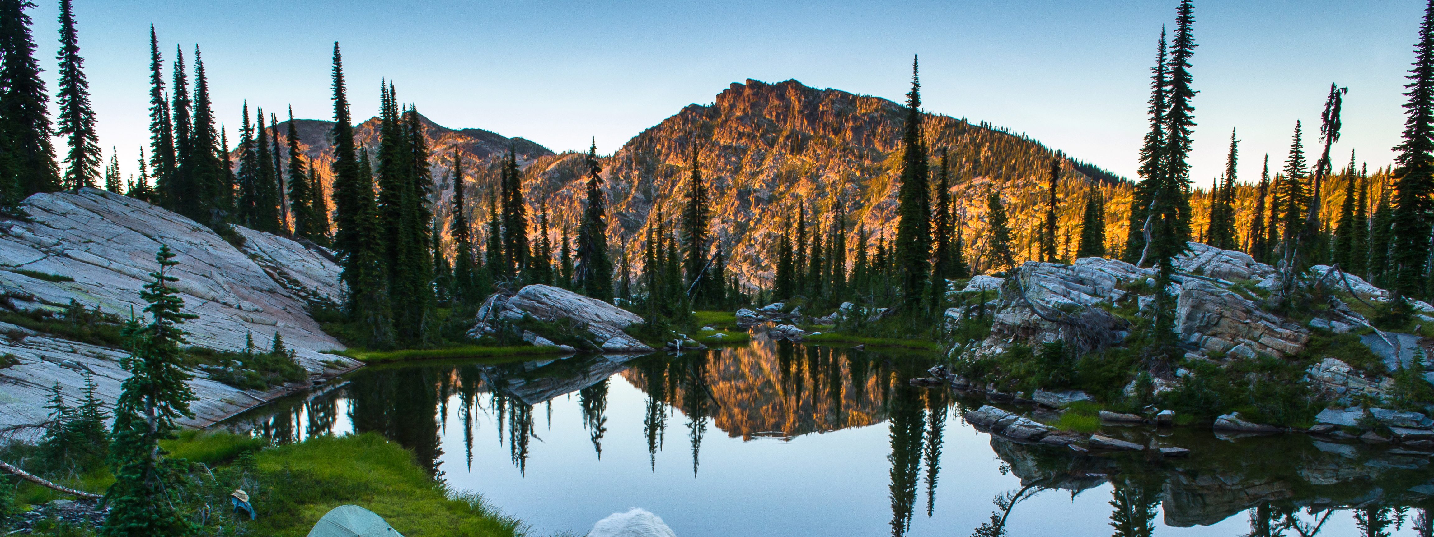
 Dusk blankets the peaks above Horseshoe Lake in Montana’s sector of the Scotchman Peaks Proposed Wilderness Area. (Photo by Aaron Theisen, courtesy of Idaho Conservation League)
Mapped in 1809 by famed explorer, merchant and geographer David Thompson, this is the traditional land of the Kootenai Indians. Fur traders trapped the waterways, gold seekers washed gravel from the gulches in the 1870's, and in 1893 the Great Northern Railroad came through, bringing permanent settlers.
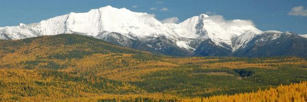
Located in the state’s northwest corner, the Bull River harbors some of our most productive forests. Timber reaches up to the highest points. And this is Montana’s wet country: 50 to 100 inches of annual rainfall nourishes an old growth rain forest, producing lush vegetation and an enormous variety of native plants. Yet it is also a land of contrast: Big fir trees and western red cedars, products of high precipitation areas, grow just a short way from Douglas firs and the western larch of dryer climatic zones. It is best described as an area where the more arid landscape of the Northern Rocky Mountains begins a transition to the moist environs of the Pacific Northwest.
Human presence is sparse, but caribou, grizzlies, wolves, moose and an abundance of other wildlife call it home. It is, at once, heavily logged and yet a pocket of pristine wilderness. Montana’s “north woods” are alive and well here.
Highway 56, the Bull River Valley road, stretches for 35 miles between Montana Highway 200 and the Cabinet Gorge of the Clark Fork River and U.S. Highway 2, skirting the Kootenai River. This former Indian trail provides access to the wild country rising on either side of the valley.
One of the star attractions is the Ross Creek Cedar Grove, located just south of Bull Lake and four miles west of Highway 56 in the west Cabinet Mountains. Here, giant cedar trees, some more than 8 feet in diameter and 175 feet tall, flourish in a protected pocket on either side of the creek. Many were growing before Columbus reached the Americas. Other large trees contribute to the veiled canopy, and the forest floor is covered with ferns and flowers. A 1-mile-long self-guided nature trail makes a loop through an emerald setting.
Often portrayed as having a cathedral ambiance, sunlight filters through the towering timber and verdant vegetation, evoking serene feelings. Gnarled roots and twisted limbs would be excellent homes for elves and gnomes. All attention is focused on what is at hand – no awesome vistas, only simple beauty. To walk through after a rain shower or to glide through on cross country skis with soft snow falling makes for a very special experience.
Trails follow the Middle Fork and South Fork of Ross Creek, leading from the big trees into the high country. Lower stretches of the creeks are known for their native cutthroat trout.
The road that works its way up into the grove of 500-year-old behemoths allows for several excellent viewpoints of the summits across the Bull River Valley. This is the magnificent and federally designated Cabinet Mountain Wilderness Area – a fitting eastern boundary. The peaks of the wilderness area ascend close to 9,000 feet.
Rising directly above and west of the Cedars, is the Scotchman Peaks section of the Cabinet Mountains. Shared with Idaho, more than 86,250 acres of this unprotected, roadless area are in Montana. The clean, clear waters of Ross Creek emanate from these rugged and wild alpine peaks.
Compared to other Montana mountains, elevations are low: The highest is 6,900-foot Savage Mountain. Most of the tops are only between 6,000 to 6,500 feet. In some cases though, the drop-off is more than 4,000 feet to the river bottoms. Scotchman Peak, in Idaho’s section, registers 7,000 feet in height.
Although the Scotchmans see plenty of rain and snow, they have only one named body of water, Little Spar Lake. There is plenty of evidence that glaciers once existed here. The upper Ross Creek Canyon is U-shaped as if once filled with an alpine glacier.
The route through the Bull River Valley shows many outstanding views of the mountains on either side. Bull Lake, found midway, was formed by a landslide, and presents an invitation to canoe or kayak along its western shore. Bull River, head watering in the Cabinet Wilderness, enters the valley just to the south of Bull Lake and meanders to the Clark Fork. Lake Creek drains from Bull Lake to the Kootenai River on the north.
Most of this Bull River country and mountain region is public land managed by the U.S. Forest Service. Get to know it. Your support is needed to protect its wild characteristics and roadless areas. There are several campgrounds and places nearby to stay. Lodging can be found in Troy and Libby. For more information and maps, contact the Kootenai National Forest at 31374 US Hwy 2 West, Libby, MT 59923 or call 406-293-6211.
Rick and Susie Graetz | University of Montana | Department of Geography