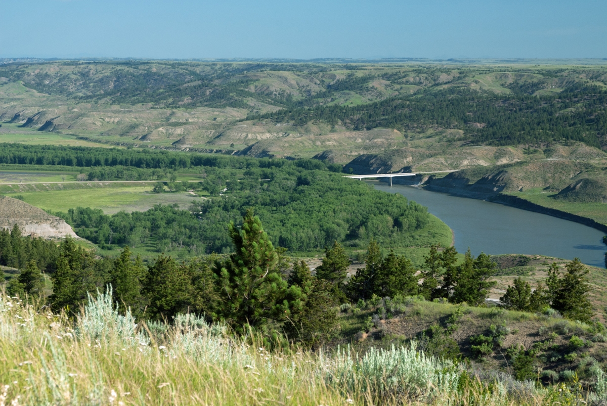
 Kipp Landing and the Fred Robinson Bridge (Photo by Rick and Susie Graetz)
Few names are more prominent in Missouri River history than James Kipp. Born in Montréal in 1788, he was a fur trader, fort builder and steamboat captain. In 1831, he established Fort Piegan, 128 river miles above Kipp Landing at a point where the Marias River meets the Missouri. It was the first American Fur Company trading post on the Missouri River west of Fort Union, located on the current Montana-North Dakota border.
The following spring Kipp returned downriver with more than 4,000 beaver pelts and many other smaller furs. He retired in 1859 after 41 years in the fur trade business and died in 1880.
James Kipp Recreation Area, better known as Kipp Landing, is named for him.
The area is at mile 149 of the Upper Missouri River Breaks National Monument and the place where floaters take out after making the six-day trip from Coal Banks Landing at mile 42. Floaters putting in at Judith Landing travel 61 miles and usually take three to four days to reach Kipp.
Before this location took on James Kipp’s name, it was a place for steamboats to “land” and offload passengers and cargo when they could no longer navigate westward. Low waters and lack of fuel were the main issues. These big crafts could burn 30 cords of wood in 24 hours. The goal of sternwheelers passing here was Fort Benton, but often they were forced to turn around at various places well below “Benton,” hence the name “landing.” People and cargo had to then travel overland on wagons and stagecoaches to reach Fort Benton.
There were two other landings just downriver from Kipp – Rocky Point and, just below that, Fort Carroll. The Carroll Trail connected to Rocky Point and Kipp Landing. Today, following the dirt road (not passable when wet) from the Charles M. Russell National Monument field office at Sand Creek south of the bridge and up on a bench high above the Missouri, one can travel parts of this clearly marked old trail. The CMR field office has maps.
Until 1860, all river travel west of Fort Union was a difficult, physical task. Most travelers had to literally pull the boats against the current. But in 1860, the high waters of that summer brought the steamboat Chippewa to Fort Benton, proving the treacherous Missouri River to be navigable to that point. Over the next 30 years, tons of supplies and thousands of people came to central Montana on the steamers. The boats returned downriver with the wealth of the frontier – gold, pelts, buffalo robes and eventually beef and wool.
As well as serving those going east or west, the Missouri River was a major obstacle to north and south travel. Until late in the 1950s, ferries provided the only way of crossing the river between Fort Benton and Fort Peck – a distance of almost 300 miles. The ferries proved quite dependable, except when the water was too high, too low or frozen.
Then in 1959, the Fred Robinson bridge spanning the Missouri and bordering Kipp Landing on its west side was completed. It was named for Fred Robinson of Malta, a state senator for 40 years and the driving force behind its construction.
Save for the sound of light traffic crossing the bridge, Kipp Landing today is a quiet place much of the year. Trek less than a mile up or down river and experience a landscape that hasn’t changed since the Corps of Discovery, moving against the current, went by here on May 24, 1805, and camped just 2.5 miles upriver. The murmur of the river and birds make up the soundscape.
Rick and Susie Graetz | Department of Geography | University of Montana
(Historical notes courtesy of the UMRBNM and the BLM)