Data Products
Our philosophy and policy of datasharing is closely aligned with the National Science Foundations – Long-Term Research in Environmental Biology’s program policy. Most of our core data from our first 15 years is already publicly available, and we work to update it as much as possible through various sources that we highlight below.
Data Management Plan
1. Database (DB) Description & Standards
We designed relational databases to ensure data quality (input masks, data checking queries, password protection to changing data, data entry templates), portability using GoogleForms and GoogleDrive between our remote field site (with limited satellite-only internet) and master databases (through parent-child DB structure), security (password protected), and accessibility with shared metadata standards with Parks Canada (Microsoft ACCESS database structure). We screen incoming GPS data for errors using automated R scripts (1) and have developed R code to easily integrate GPS radiocollar data from different brands/models into our Movebank GPS platform. We next describe data availability for our four main long-term data described in our Results from Previous NSF Support.
First, our long-term vegetation biomass data are stored in a GoogleDrive, ACCESS-compatible databases and are publicly available, updated annually (2, on the Dryad website). Our vegetation data includes spatial model predictions of biomass in 16-day periods growing season dynamics available as RASTER files (with metadata) for 2002–16 on GoogleDrive. These require annual updating due to fire/landcover change. We are currently updating these models because of an landcover model developed by Parks Canada. We anticipate completing updates within 1 year of the end of the first 5 years of LTREB funding, and making these publicly available then, though already share the 2002 – 2016 data.
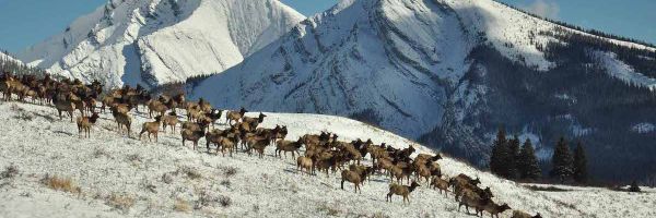
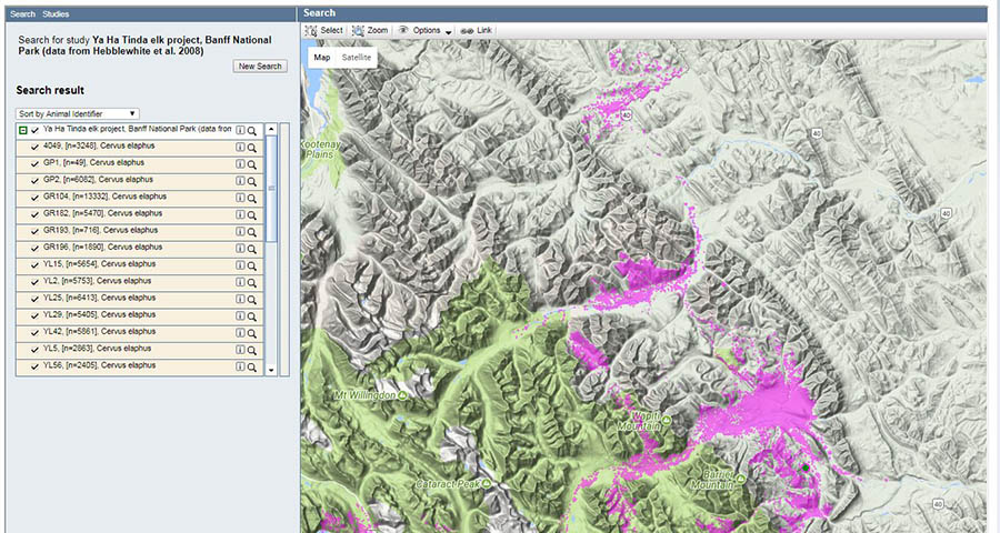
Our second major data stream is our spatial GPS telemetry database for adult female GPS radiocollared elk, > 1.6 million locations. These data are also publicly accessible on MOVEBANK (3, on the Dryad website), though with some lagtimes (currently ~2019) because Iridium satellite uploads are often incomplete (only ~ 65% of locations), completed only upon death of elk or retrieval of radiocollar.
Third, our demographic data are stored in relational databases that link individual female elk ID to individual-level data (i.e., animal capture, time and cause of death, age, pregnancy, mark-resight juvenile elk survival, etc.). There are also associated population-level demographic data including aerial winter counts, and recruitment ratio (calf:cow data). Demographic data at both individual- and population-level are also publicly accessible (4, on the Dryad website), along with our annual summary estimates. Again, there are often lags for some demographic data > 1-3 years because of unknown ages, failed radiocollars with data stored on board, etc. We anticipate updating these demographic data with the publication of the main scientific paper from our first 5 years (5).
Fourth, our long-term predation risk monitoring is accomplished via two main datasets. Our long-term remote camera trapping data, and second, GPS radiocollared wolves. For our entire study area, we collaborate with Parks Canada’s remote camera trapping data which they share with us through a Data Sharing Agreement, and thus is not ours to distribute. However, for the portion of our study area on provincial lands for which we collect remote camera data from ~ 30 camera’s, these data have already been made publicly available (6, on the Dryad website), and our long-term goal is to make these data publicly available within 1 year of the end of our first 5-year LTREB. This is because of even longer lag times in accessing remote camera’s (i.e., we have yet to access camera’s deployed in Fall of 2019 yet due to high snowpack and dangerously high flooding preventing river crossings), image classification and processing, and database management. These delays usually take 1-1.5 years, and we coordinate with Parks to do our annual database ‘roll-up’ concurrently. Nevertheless, we have already shared data from 2012 – 2017 with 4 other research groups. Finally, we also archive the following long-term samples; elk teeth samples (UofMontana), elk and wolf hair (stable isotope) and blood samples, and herbarium samples (U. of Alberta).
2. Scientific Data Sharing, Accessibility and Sharing Policies
Our philosophy and policy of datasharing is closely aligned with the LTREB program’s policy. Almost all of our core data from our first 5 years is already publicly available, and we are committed to completing the first 5 years and making it easy to access through our updated project website by the end of our first 5-year grant. All data we collect on this project is required to be shared with the Canadian Public as part of Parks Canada data-sharing policies governed under our Federal research permit. Our policy must also respect existing Parks Canada permits who allow us sole license up to 3-years following collection (to protect current graduate students intellectual investment), and co-ownership thereafter. We also adhere to some restrictions on data accessibility required under permit by Parks Canada (e.g., not publishing real-time locations of elk during hunting seasons, wolf dens, etc.). We have entertained all requests to collaborate, synthesize, and share data actively, which have led to many valuable ecological syntheses (7-12). Practically, we also actively share data with the dozens of different research teams (9, 13-16). Our data were also made openly available to workshops on R and spatial analyses at the International Conservation Biology Congress in Cartagena, Columbia (17). Finally, the PI will make LTREB datasets part of his open source, under-contract Book on Animal Resource Selection in R (by Cambridge University Press). Near the end of our LTREB Renewal, we propose to prepare an Ecology Data Paper for all LTREB datasets. Finally, all R and JAGS (open-source software) code is published, with data, in project publications.
3. Web-Application Integrated Population Model
Our final new activity in our Renewal proposal will be overcoming a challenge in ‘sharing’ demographic data and advances in our IPM with the broader community. Scientific publications often only require the raw data and core R code is available. Yet the computational architecture required to efficiently use IPM’s for ecological synthesis are a significant barrier to technology transfer. We will develop a stand-alone, web-based R Shiny App (18, 19) of our IPM for open public access. Collaborating agencies, other environmental management groups and scientific collaborators will be able to easily access and reproduce all of our IPM results, download data, propose new model structures, and fit IPMs to our LTREB data. This will facilitate technology and data transfer and foster collaboration amongst the broader scientific community.
References
- Bjorneraas et al., Screening Global Positioning System Location Data for Errors Using Animal Movement Characteristics. J. Wild. Manag. 74, 1361-1366 (2010).
- Weeks et al. Weeks, Trevor; Merril, Evelyn; Hebblewhite, Mark (2020), Plant Biomass data from: Bottom-up Herbivore-Plant Feedbacks Trump Trophic Cascades in a Wolf-Elk-Grassland System, v4, Dryad, Dataset, https://doi.org/10.5061/dryad.31zcrjdhr
- Hebblewhite M, Merrill EH, Martin H, Berg JE, Bohm H, Eggeman SL (2020) Data from: Study "Ya Ha Tinda elk project, Banff National Park, 2001-2020 (females)". Movebank Data Repository. https://doi.org/10.5441/001/1.5g4h5t6c
- Martinet al. Martin, Hans; Hebblewhite, Mark; Merrill, Evelyn (2020), LTREB: Yaha Tinda Elk Project, Dryad, Dataset, https://doi.org/10.5061/dryad.6wwpzgmw7
- Martin, H.et al., Ideal free migration?? testing for density-dependent migration in partially migratory elk. Ecol.Lett.In Preparation, (2020).
- Steenweg et al., Camera-based occupancy monitoring at large scales: Power to detect trends in grizzly bears across the Canadian Rockies. Biol. Cons. 201, 192-200 (2016). Dryad, Dataset, https://doi.org/10.5061/dryad.64p5c
- Vucetich et al., Predicting prey population dynamics from kill rate, predation rate and predator-prey ratios in three wolf-ungulate systems. J. Anim. Ecol. 80, 1236-1245 (2011).
- Aikens et al., Wave-like patterns of plant phenology determine ungulate movement tactics. Current Biology In Revision, (2020).
- Tucker et al., Moving in the anthropocene: global reductions in terrestrial mammalian movements. Science 359, 466-469 (2017).
- Rich et al., Assessing global patterns in mammalian carnivore occupancy and richness by integrating local camera trap surveys. Glob.Ecol. Biogeog. 26, 918-929 (2017).
- Brodie et al., Relative influence of human harvest, carnivores and weather on adult female elk survival across western North America. Journal of Applied Ecology 50, 295-305 (2013).
- Griffin et al., Neonatal mortality of elk driven by climate, predator phenology and predator diversity. J. Anim. Ecol 80, 1246–1257 (2011).
- Rogala et al., Human activity differentially redistributes large mammals in the Canadian Rockies. Ecology & Society 16, 16 (2011).
- Aikens, e. al., Wave-like patterns of plant phenology determine ungulate movement tactics. Current Biology In Press, (2020).
- Barrueto et al., Anthropogenic effects on activity patterns of wildlife at crossing structures. Ecosphere 5, (2014).
- Clevenger et al., Performance Indices to Identify Attributes of Highway Crossing Structures Facilitating Movement of Large Mammals. Biol. Cons.121, 453-464 (2005).
- Gurarie et al., Workshop at the International Conservation Biology Congress, Cartagena, Columbia., 2017.
- Eacker et al., Web-based application for estimating threatened woodland caribou population trends. Wildl. Soc.Bull. 43, 167-177 (2018).
- Nowak et al., Customized software to streamline routine analyses for wildlife management. Wildl.Soc.Bull. 42, 144-149 (2017).