
Project Summary
The VIIRS sensors aboard the NASA/NOAA Suomi NPP (SNP) and NOAA-20 (JPS) satellites have been collecting multispectral visible and infrared global Earth imagery since 2012. VIIRS provides for continuity in Earth observations originally collected from the NASA EOS MODIS sensors and provides continuous, well-calibrated global environmental data records spanning multiple decades. NTSG supports the VIIRS mission as a member of the NASA Land Discipline Team and SNP/JPS Product Maintenance Team, providing science and technical support for the VIIRS GPP/NPP/ET land products. We originally developed these products for operational production using MODIS observations from the NASA EOS Terra and Aqua satellites. The NASA MODIS MOD/MYD16 and MOD/MYD17 operational products provide respective global daily estimates of land evapotranspiration (ET), vegetation gross primary production (GPP), and net primary production (NPP) at 500m spatial resolution. Together, these products quantify trends in vegetation growth and land-atmosphere energy water, and carbon (CO2) exchange in response to changing climate conditions. Similar products derived using VIIRS observational inputs (VNP16, VNP17) are now operational from the NASA/NOAA VIIRS missions. The VNP16/17 products from VIIRS will continue to provide continuity in these critical environmental data records beyond the NASA EOS era.
Images
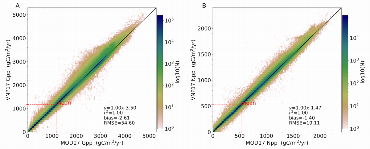
Above left: VIIRS VNP17 GPP compared to MODIS MOD17 GPP; above right: same but for NPP.
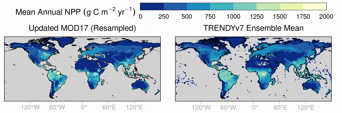
Above: Mean annual NPP (2000-2018) from new MOD17 Collection 7 compared to the same estimate from the TRENDYv7 ensemble of dynamic global vegetation models, taking the mean across all models. Global gridded NPP from VNP17 and MOD17 agree well and built-in bias correction enables continuous GPP, NPP estimates from 2000 to present.
Selected Publications
Endsley, K.A., M. Zhao, J. Kimball, and S. Devadiga, 2023. Continuity of global MODIS terrestrial primary productivity estimates in the VIIRS era using model-data fusion. JGR Biogeosciences (open the PDF)
Roman, M., C. Justice, I. Paynter, P. Brehm Boucher, S. Devadiga, A. Endsley, A. Erb, M. Friedl, H. Gao, L. Giglio, J. Gray, D. Hall, G. Hulley, J. Kimball, Y. Knyazikhin, A. Lyapustin, R. Myneni, P. Noojipady, J. Pu, G. Riggs, S. Sarkar, C. Schaaf, D. Shah, K. Tran, E. Vermote, D. Wang, Z. Wang, A. Wu, Y. Ye, S. Yu, S. Zhang, S. Zhang, X. Zhang, M. Zhao, C. Davidson, and R. Wolfe, 2024. Continuity between NASA MODIS Collection 6.1 and VIIRS Collection 2 products. Remote Sensing of Environment, 103, 113963.
NTSG Personnel
John Kimball, K. Arthur Endsley, Steve Running