Project Summary
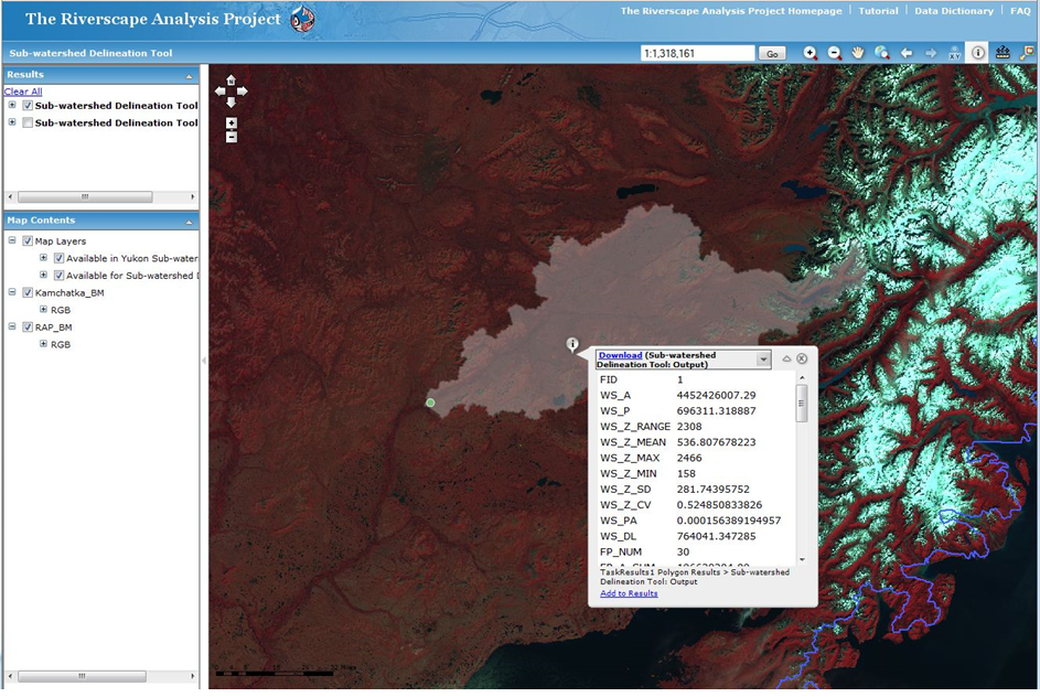
The Riverscape Analysis Project (RAP) is a web-based GIS Decision Support System that will assist in salmon conservation across the North Pacific Rim (NPR), based upon a robust classification (typology) of rivers and river habitats which is aimed at conserving the existing potential production of salmon in the context of the ocean domains influencing the rivers and salmon that spawn and rear in them. Funding for this project was provided by the Gordon and Betty Moore Foundation.
Selected Publications
Wade, A.A., T.J. Beechie, E. Fleishman, N.J. Mantua, H. Wu, J.S. Kimball, D.M. Stoms, and J.A. Stanford, 2013. Steelhead vulnerability to climate change in the Pacific Northwest. Journal of Applied Ecology, 50, 5, 1093-1104.
Whited, D., J.S. Kimball and J.A Stanford, 2013. Estimation of juvenile salmon habitat in Pacific Rim rivers using multi-scalar remote sensing and geospatial analysis. River Research and Applications 29, 135-148.
Whited, D.C., J.S. Kimball, J.A. Lucotch, N.K. Maumenee, H. Wu, S.D. Chilcote, and J.A. Stanford, 2012. A riverscape analysis tool developed to assist wild salmon conservation across the north pacific rim. Fisheries 37 (7), 305-314 (cover article).
Wu, H., J.S. Kimball, M.M. Elsner, N. Mantua, R.F. Adler, and J. Stanford, 2012. Projected climate change impacts on the hydrology and temperature of Pacific Northwest rivers. Water Resources Research 48, W11530.