
Landsat Land Cover
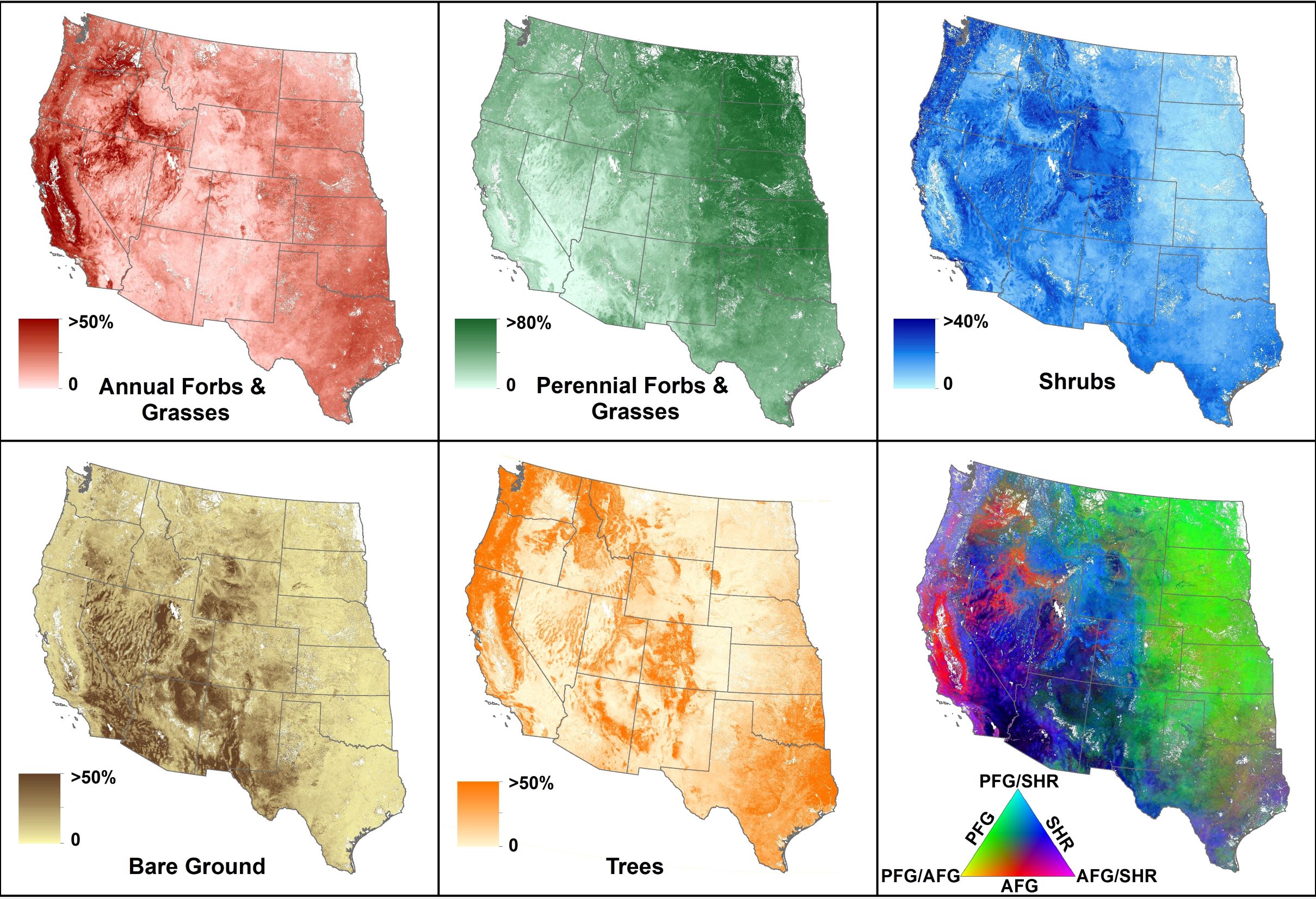
Land cover maps are essential tools for tracking land surface changes, informing land management, monitoring environmental conditions, and assessing conservation efforts. Current products, however, lack essential spatial or temporal resolutions required for such efforts. The categorical classes in a majority of these maps also fail to capture the inherent heterogeneity of the land surface. To address the need for high spatial and temporal resolution land cover maps that capture natural landscape variation, we produced annual, 30 meter, continuous land cover maps for U.S. rangelands from years 1984 to 2017. We used over 30,000 vegetation plots from the NRCS National Resources Inventory and BLMAssessment Inventory and Monitoring spanning years 2004-2016 to train and validate machine learning regression model. We capitalized on a cloud-based platform for planetary-scale geospatial analysis with massive computational capabilities (Google Earth Engine) to process and store over 250 spatially contiguous gridded climatic, biotic, and abiotic spatiotemporal variables (inclusive of satellite remote sensing data) to drive the model. The resulting yearly maps provide percent cover of annual and perennial herbaceous vegetation, shrubs, bare ground, and trees for U.S. rangelands, inclusive of the Great Plains. The modeling framework allows for annual generation of land cover maps into the future. These maps provide essential information for rangeland management and conservation, and will be used to create a 30 meter spatial resolution primary productivity model optimized for rangeland vegetation.
The land cover maps can be accesses via the Rangeland Analysis Platform https://rangelands.app), a free online application that provides simple and fast access to geospatial data of western U.S. rangeland resources. The tool was developed to provide landowners, resource managers, conservationists, and scientists access to data that can inform land management planning, decision making, and the evaluation of outcomes. The Rangeland Analysis Platform (RAP) uses innovative cloud computing technology to provide maps and analysis opportunities straight to your desktop, delivered securely and instantaneously.
NTSG Personnel
- Matthew O. Jones
- John Kimball
- David Naugle
Publication
Jones, M. O., B. W. Allred, D. E. Naugle, J. D. Maestas, P. Donnelly, L. J. Metz, J. Karl, R. Smith, B. Bestelmeyer, C. Boyd, J. D. Kerby, and J. D. McIver. 2018. Innovation in rangeland monitoring: annual, 30 m, plant functional type percent cover maps for U.S. rangelands, 1984-2017. Ecosphere 9:e02430.